Looking for a new outlook on our territorial history? See what archeology reveals about the new people who came into Nebraska beginning in 1854. Five territorial-era towns and one rural mill were discovered buried in the path of planned transportation improvements beginning in the early 1970s. The State Archeology Office and the Nebraska Department of Transportation teamed up to investigate the buried ruins. We share summaries below, along with historical background. Archeological data enhances the scant archival records and lets us capture a more robust and accurate understanding of the lives of these pre-1867 Nebraskans.
Solving archeological problems often involves evaluating data from a ‘suite’ of related sites studied over a period of years. The territorial period archeology program is a wonderful example of that reality. Taken together, the artifacts, bones, and other field observations gathered at these six sites now allow for a productive understanding of material culture, subsistence, technology, socioeconomic levels, and architecture that simply cannot be gleaned from the archival record alone. The investigations have also resulted in important baseline information for identifying collections of tableware, bottles, window glass, and smoking pipe forms from future territorial period and early statehood excavations.
Historical background: In the spring of 1854, the United States Congress passed the Kansas-Nebraska Act organizing the two future states as territories. The purpose of the act was to open the region for rural agricultural and urban settlement paving the way for a planned transcontinental railway. At about that time, most native lands in eastern Nebraska were ceded to the US government. Prior to the act, Euroamericans in what is now Nebraska included only traders, fur trappers, missionaries, military units, those passing along the emigrant trails, and occasional squatters. With the notable exception of a few fur trading posts, stage stations, and forts, Euroamericans had left a very sparse archeological record prior to the mid-1850s.
Almost immediately after territorial designation, fledgling towns, ferries, farms, and small rural businesses such as flour and saw mills began to spring up, mostly along the Missouri River and the lower reaches of its tributaries. Bellevue was the only ‘town’ already established; it began as a fur trade post in the 1820s. Soon Plattsmouth, Omaha, and Nebraska City sprang up. The first territorial legislature granted charters to seventeen of these would-be cities. Many are considered “paper towns”–chartered and platted but other than a few cabins and businesses, the towns never really materialized. The territorial period lasted for slightly less than thirteen years until Nebraska became a state in March of 1867. After statehood, the archival record of early Nebraska increases dramatically with an abundance of newspapers, journals, photographs, public records, and maps.
Cuming City
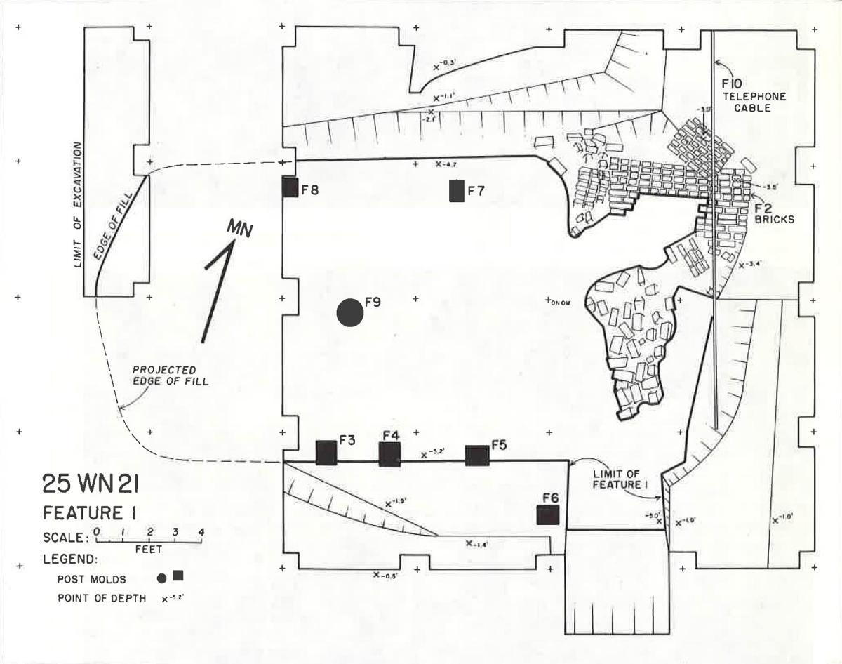
Plan view map of an archeological excavation of a buried Cuming City cellar.
In 1855, a town company was fomed and plans drawn for Cuming City. The original plan called for 180 blocks. It is not known how many blocks were actually developed but within several years several stores, hotels, saloons and over 50 homes appeared (Bell 1876:43). When the railroad was built through neighboring Blair, Cuming City’s population quickly dwindled. By the 1880s several buildings remained extant, but all were gone by 1900.
Widening of US HIghway 73/75 in 1974 required archeological investigations in old Cuming City under the direction of NSHS staff Gayle Carlson and Terry Steinacher (Steinacher and Carlson 1984:87-114). The field work focused on a deep subfloor cellar that had been beneath a house or commercial building. A diverse assortment of glass, metal, and ceramic artifacts suggested a period of occupation in the mid-1860s. The collection was the first of its age to be recovered from a territorial period site in Nebraska and formed a useful comparative basis for subsequent territorial period research.
De Soto
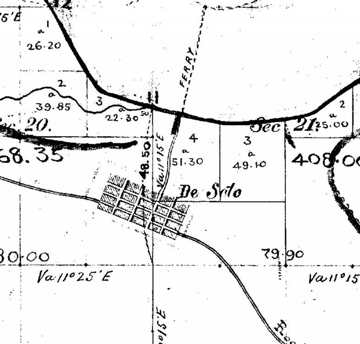
1856 General Land Office Survey (GLO) plat map depicting the town of De Soto.
While Cuming City was being developed north of what would become Blair, construction also began in the town of De Soto in 1855. Within a few years, De Soto consisted of 30 log buildings including homes, a hotel, two general stores, several banks, a school, and at least a dozen saloons! The town began to decline by 1859, partially in response to the discovery of gold in Colorado. By 1870, it was completely abandoned and all buildings had been removed and many were re-located to prospering Blair (Bell 1876: 37-39).
Archeological investigations were conducted by Steinacher and Carlson in 1975 in response to relocation of US-73. Even more archeological features and artifacts were recovered than at Cuming City. Over twenty features were found during mechanical topsoil stripping. Eleven became the focus of controlled excavations including five building cellars, a deep outhouse pit, four refuse trenches, and a large post mold. The recovered collection is extensive and includes a diverse assortment of animal bone, ceramics, glass, metal and other materials (Bozell and Ludwickson 1990:17). The collection has not been formally studied but select samples have been the subject of several University of Nebraska-Lincoln student laboratory projects and papers.
Brownville
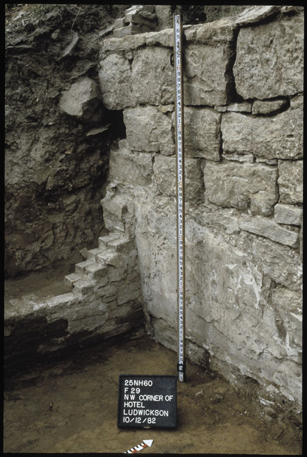
Floor of hotel basement excavation at Brownville.
Brownville, also known as the “City of Seven Hills,” was founded by Richard Brown in 1854. It soon developed into an important center for milling and overland and steamboat traffic. While the town saw some rough economic times, it remained viable due to the local fruit industry, steady barge traffic, and construction of a Missouri River bridge in 1930. Today Brownville is a locally vibrant center for art, culture, and history. It is the only territorial-era townsite to be the subject of archeological investigations that remains occupied. Much of the town is a National Register of Historic Places District.
Proposed reconstruction of US Highway 136 and Brownville’s Main Street triggered systematic excavations in 1982 to mitigate an adverse effect to the archeological component of the historic district designation. The work was under the direction of John Ludwickson and Steve Holen (Bozell and Ludwickson 1990:23-25). Highway construction plans were carefully reviewed in relation to historic photographs and maps and it became apparent the construction had the potential to impact up to eleven former structures related to the territorial and early statehood period. Field investigations ultimately focused on excavations at the buried ruins of a hotel, a bakery, two stores, and trash-filled outhouse pits and a cistern. In addition to a very large artifact collection, these investigations resulted in recovering important architectural information.
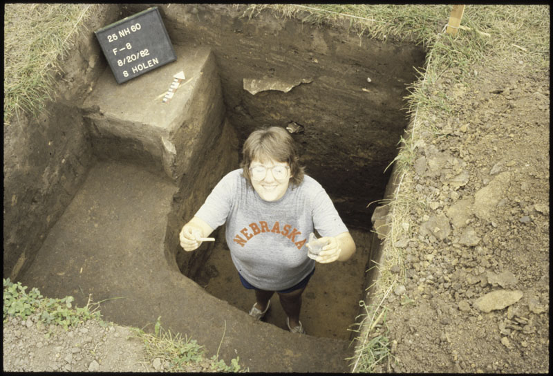
Excavated outhouse pit at Brownville Townsite. Crew member is holding a smoking pipe and whiskey glass found at bottom of the pit.
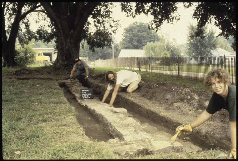
Archeology crew beginning excavation of a building foundation at Brownville.
Platteford
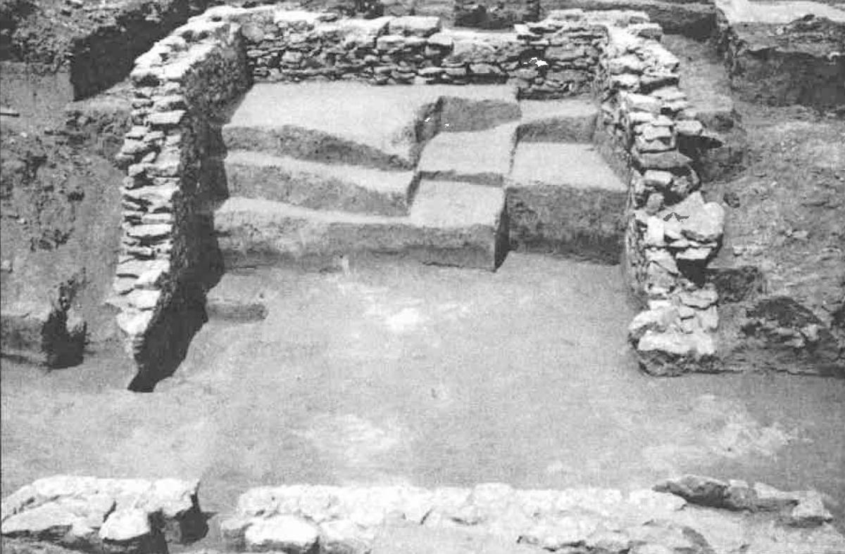
Platteford foundation, view to the north.
A former town on the Platte River, Platteford was platted in 1857. Construction began the same year. A hotel was built and Platteford became the location of a ferry across the Platte. Archival records are scant but imply that the town never consisted or more than a few buildings and homes. It was occupied for only a few years in the late 1850s.
Highway N-31 east of Louisville was programmed for widening and reconstruction in 1995. The Nebraska State Historical Society contracted with the University of Nebraska-Lincoln to bring an archeology fieldschool to search for and excavate any remains associated with Platteford (Bleed et al. 2008). A limestone foundation was discovered which clearly related to the 1850s based on the type of ceramics, bottles, and tools recovered. Based on its size and the rather abundant collection of animal bone and domestic refuse recovered, the buried foundation was almost certainly a cellar below a small home and probably one of the very residences actually built in this town.
Rockport
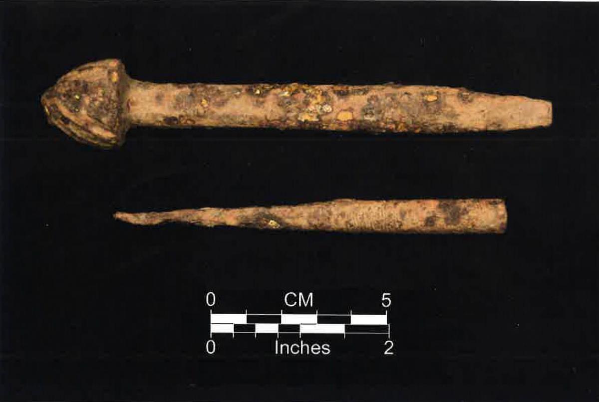
Two blacksmithing tools (countersink bit [top] and a tapered punch) recovered during Rockport excavations.
Rockport is located directly on the Douglas – Washington county line and was settled in 1857 but only remained inhabited for a few years. The town never really consisted of much more than a steamboat landing, a hotel, a lime kiln, and some saw and shingle mills. These business provided wood for steamboats and material for rural building construction. According to Missouri River maps, the small town was located on the floodplain, nestled below the bluffs immediately adjacent to the Missouri River. Archeological survey has failed to locate any remains associated with this floodplain town although any features are probably deeply buried in silt or have been washed away by the shifting river. Archival accounts do refer to scattered rural settlements in the bluffs above the town during the territorial period. These were likely small farms or acreages and loosely related to Rockport.
Planned improvement of the county “river road” above Rockport triggered an archeological search for several early Euroamerican sites including any evidence of features related to Rockport. Excavations were completed under the direction of the author in 2001 and 2002 with the assistance of University of Nebraska-Lincoln archeological field schools (Bozell and Parks 2010). Several deep depressions were tested and proved to be cellars containing 1850s and 1860s trash. They are likely related to some of the rural cabins and farms associated with Rockport. Data collected from this project provides important information on the rural aspect of territorial settlement.
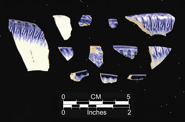
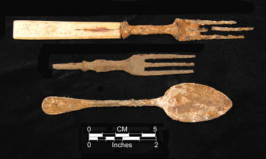
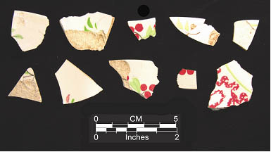
Typical Territorial cutlery and painted tableware from the Rockport Townsite.
Cowles Mill
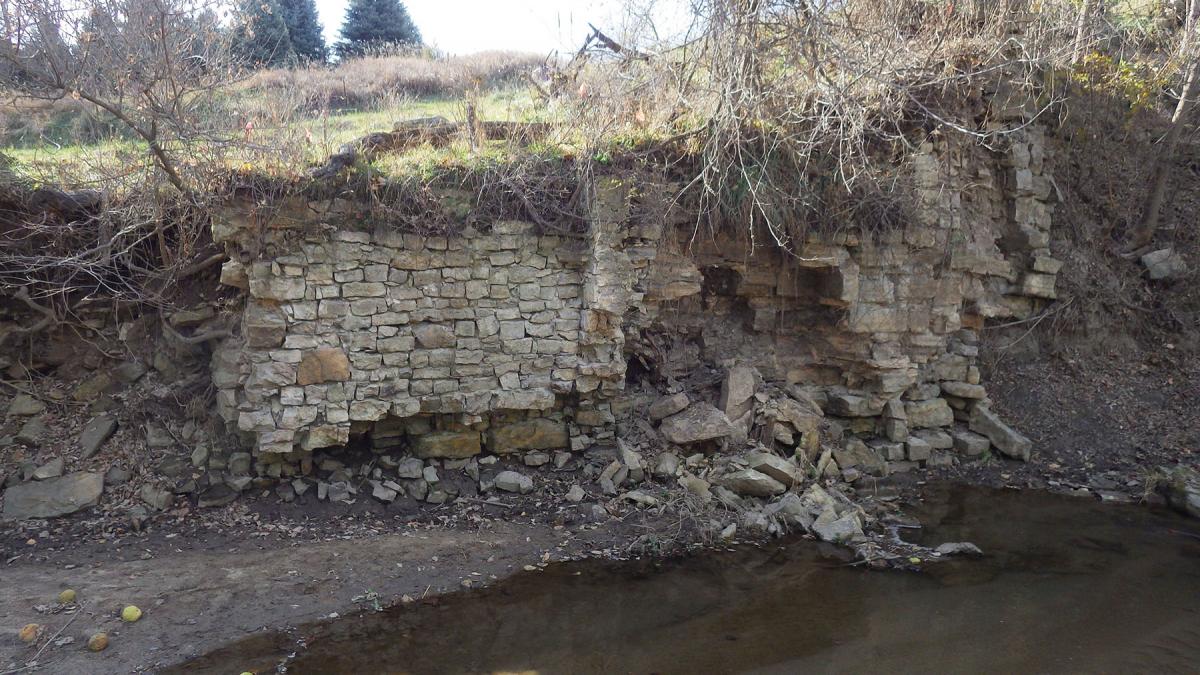
Foundation of the primary Cowles Mill building eroding from a creek bank.
This site is the only territorial period archeological resource which is not a townsite. Henry Clinton Cowles, a cabinet maker and miller from Genesee County, New York moved to the Nebraska City area in 1853. He soon built a saw and grist mill operation along Walnut Creek a couple of miles northwest of Nebraska City. By 1860, Cowles had relocated to Colorado. His mill remained in operation until the 1920s and throughout its history was the subject of various technological improvements. No buildings remain.
A substandard bridge spans Walnut Creek in the immediate vicinity of the Cowles Mill and is in need of replacement. Between 2014 and 2017, archeological documentation discovered the buried ruins of the primary mill buildings and surface and buried remnants of dams, the mill race, ponds and other features (Bozell and Mandel 2017). Limited test excavations and mapping were completed. Ultimately the main portions of the mill were avoided by construction eliminating the need for extensive excavations, but the testing and mapping has provided important baseline data for the understanding the evolution of milling from the territorial period to the 1920s.
References:
Bell, John T.
1876 History of Washington County, Nebraska. Herald Steam Book and Job Printing House. Omaha.
Bleed, Peter, Amy Koch, John Swigart, and Mary J. Adair
2008 The Archeology of Plattford, Sarpy County, Nebraska. On file, Nebraska State Historical Society, State Archeology Office. Lincoln.
Bozell, John R. and John Ludwickson
1990 A Summary of the Nebraska Highway Archeology Program for the Years 1976-1985. On file, Nebraska State Historical Society, State Archeology Office. Lincoln.
Bozell, John R. and Rolfe D. Mandel
2017 Archeological and Geomorphic Investigations at the Cowles Mill Complex (25OT505/513), Otoe County, Nebraska. On file, Nebraska State Historical Society, State Archeology Office. Lincoln.
Bozell, John R. and Stanley M. Parks
2010 Data Recovery at 25WN50 and 25WN46 in the Vicinity of the Territorial Town of Rockport. On file, Nebraska State Historical Society, State Archeology Office. Lincoln.
Steinacher, Terry L. and Gayle F. Carlson
1984 Nebraska Highway Archeological and Historical Salvage Investigations, 1969-1975. Nebraska State Historical Society Publications in Anthropology 10. Lincoln.