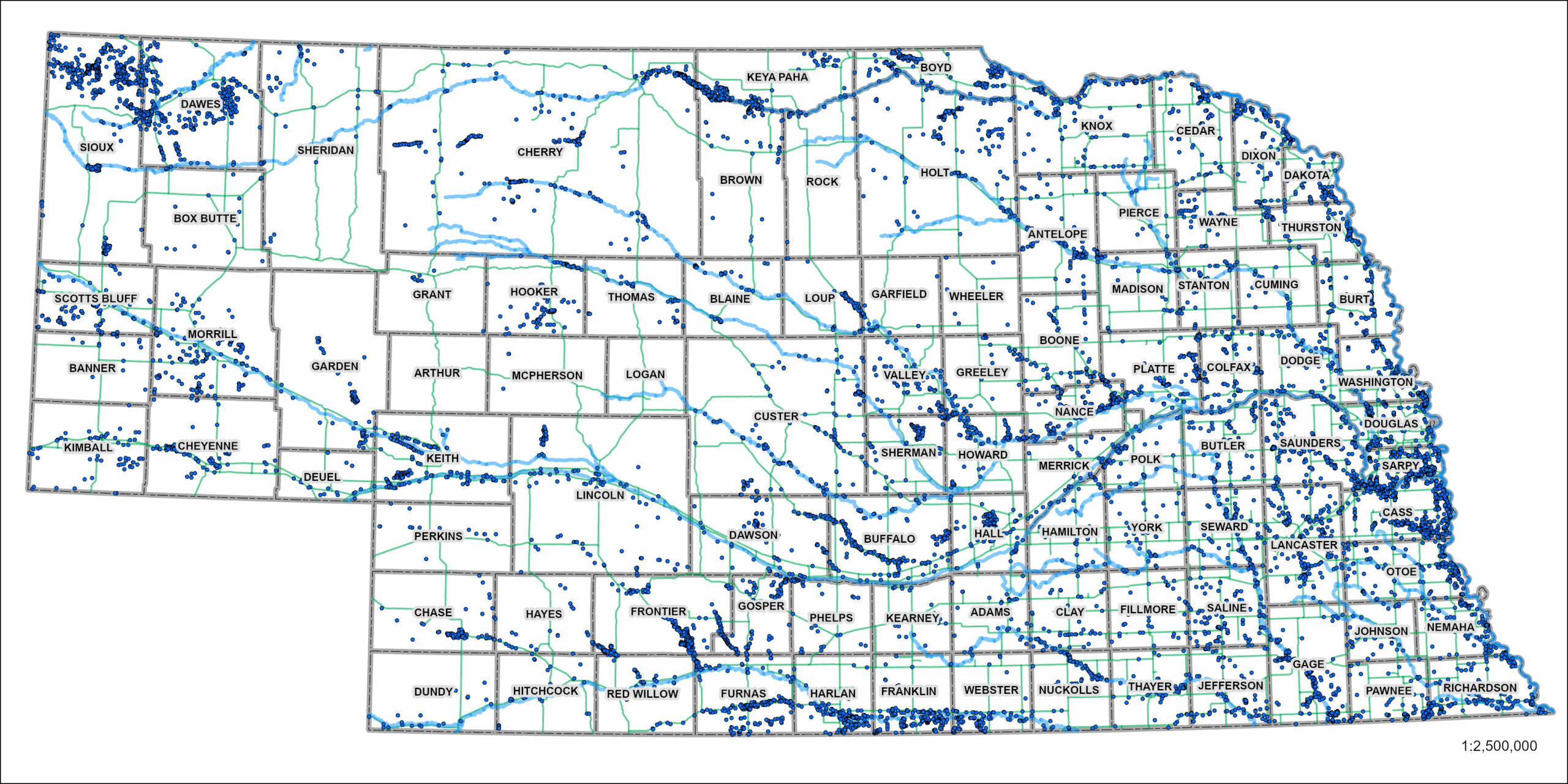
Map showing nearly 11,000 archeological sites documented throughout Nebraska. Each blue dot represents one archeological site.
One of the primary responsibilities of the Nebraska State Archeology Office (SAO), as dictated through the Nebraska Archeological Resources Preservation Act (Nebraska State Statutes 82-501510), is to maintain records and data for each archeological site found in the state. Across Nebraska, nearly 11,000 distinct archeological sites have been documented and recorded over the past several decades (FIGURE), each with its own site form, survey documentation, and digital data housed at the SAO headquarters in Lincoln. These sites range from scatters of broken plates and bottles at abandoned farmsteads to trash and storage pits, hearths, and houses from Native American sites that are thousands of years old. The approximately 11,000 recorded archeological sites represent around 13,000 years of occupation.
Nebraska is the 16th largest state by area in the nation, clocking in at around 49,500,000 acres. Some simple math tells us that, if evenly distributed, one would expect to identify one site every approximately 4,500 acres (or roughly one site per 7 square miles). As depicted in the first figure, it is clear that the documented archeological sites are not evenly distributed across the state. There are areas of Nebraska that are very dense with archeological resources and other areas with no sites present. Why might that be?
Much like the divide between rural and urban communities today, past populations tended to conglomerate in areas containing plentiful resources—water, food, wood, and stone. As a result, archeologists tend to identify archeological sites near waterways and locations known to historically contain the resources needed to survive. However, despite archeologists generally knowing where to find evidence of pre- and post-contact occupations, they are fairly limited in where they are able to survey archeological sites, particularly in Nebraska.

Map showing state, federal, and tribal lands across Nebraska.
Due to a number of state and federal laws (most notably the federal National Historic Preservation Act and its Section 106 requirements for cultural resource investigations and the Nebraska Archeological Resources Preservation Act in Nebraska, specifically), most archeological work in Nebraska is limited to public lands—those lands owned and/or managed by state and federal agencies. The combined area of public lands, as well as lands belonging to Native Nations in Nebraska, constitute only about 3 percent of the state’s area.
With permission, archeological investigations, such as those for pipeline or windfarm construction, also occur on lands owned by private citizens. Across the 49.5 million acres of land in Nebraska, only 900,000 acres have been surveyed for archeological sites. That means only about 1.8 percent of the state has been surveyed.
When we break down the total number of archeological sites documented in Nebraska compared to the total acreage surveyed in the state, we see that there is around one archeological site for every 82 acres surveyed.
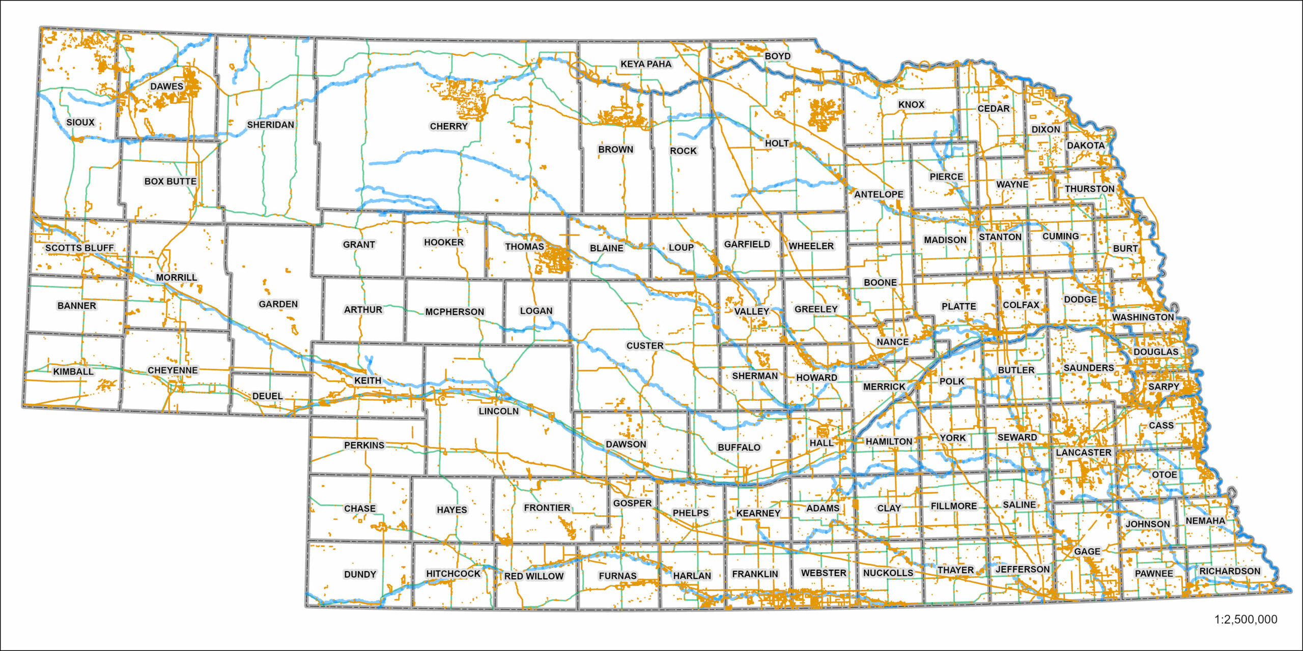
Map showing approximately 900,000 acres of archeological survey across Nebraska. Orange areas show extent of surveys.
As we have already illustrated, archeological site distribution is not equal across Nebraska based on where archeological surveys have occurred and based on resources, namely water, that would have been available for past populations. Let’s look more closely at a few counties where discrepancies in distribution are more evident.
Of the 93 counties in Nebraska, there are two that have no recorded archeological sites, Arthur and Logan counties in west-central Nebraska.
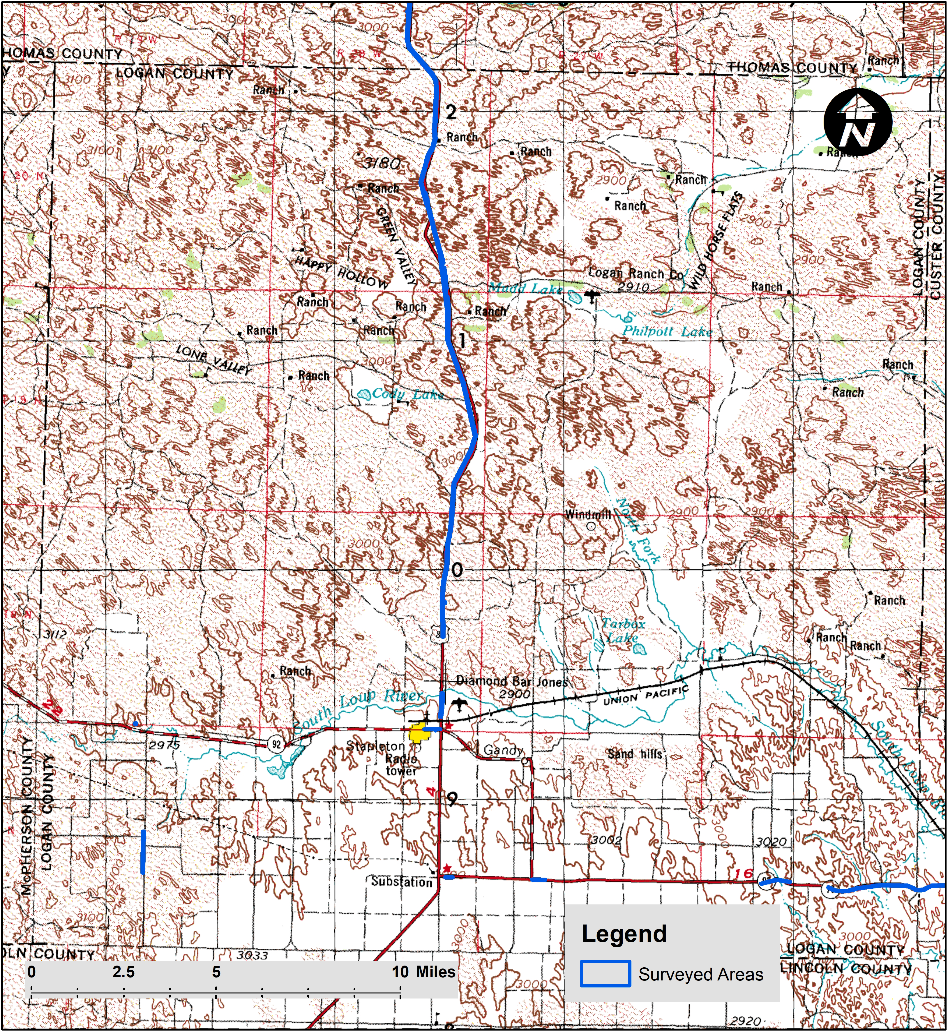
Map of Logan County showing limited number of archeological surveys.
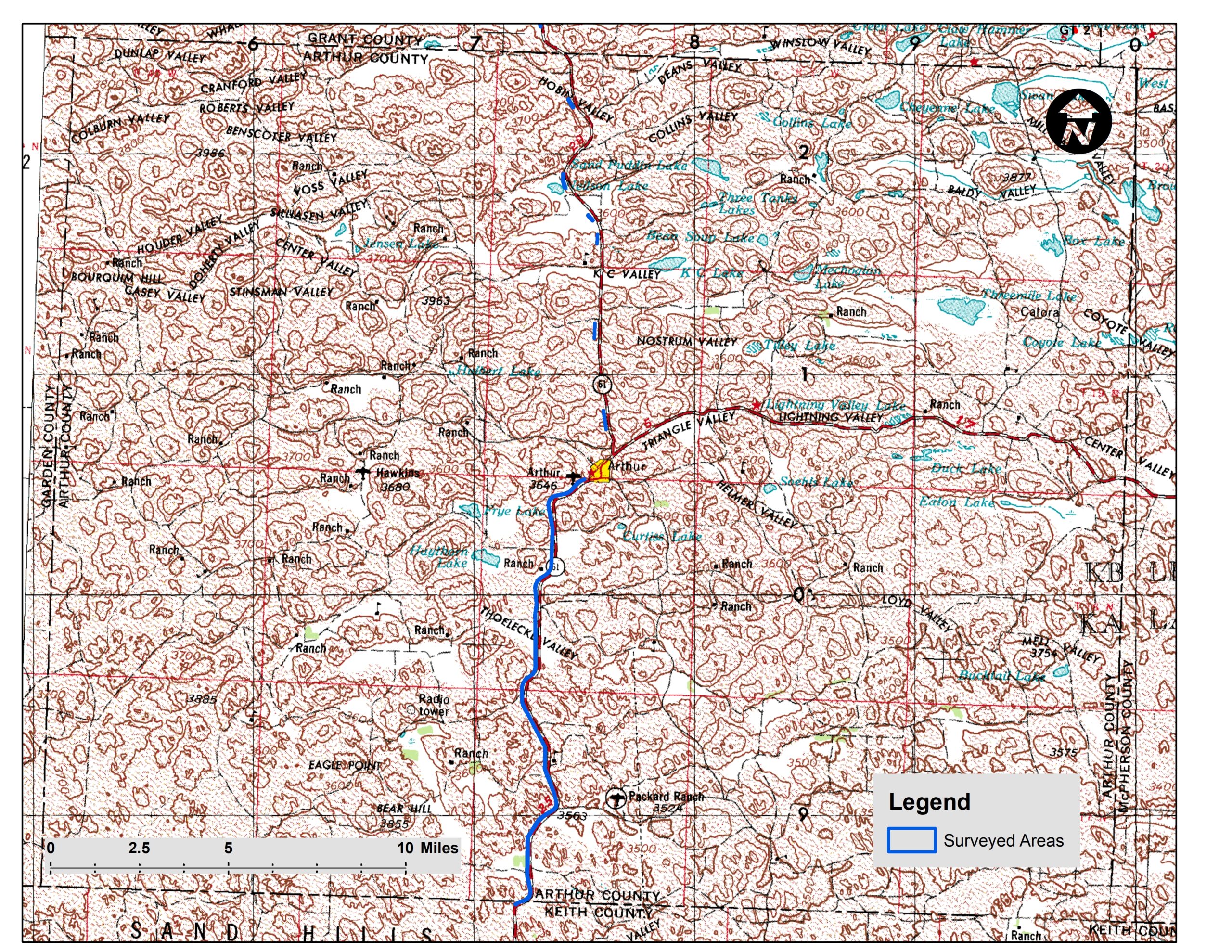
Map of Arthur County showing limited number of archeological surveys.
Conversely, Cass and Sioux Counties have the most recorded archeological sites in Nebraska, 423 and 704, respectively. Cass County, along the Missouri River in east-central Nebraska, has seen a lot of survey and has lots of water available. Sioux County in northwest Nebraska is one of the few counties in the state with large areas owned by the state and federal governments, resulting in more survey than most other counties.
These limited examples illustrate the variation in archeological site density and survey coverage across different parts of Nebraska. While the relatively small amount of public lands in Nebraska require work to document and protect archeological resources, private land ownership dominates the state. The numbers presented above demonstrate the large reliance archeologists in Nebraska have on private landowners to provide us access to their properties and either show us where they have found archeological sites, or allow us to survey areas we believe may contain archeological sites in order to continue building the archeological record of Nebraska and learning more about the deep history of the state. It is important to note that any archeological materials identified on private land belong to the private landowners; the SAO or any other archeological researcher may not permanently keep any artifacts recovered from private land. As more acres are surveyed throughout the state, new archeological sites will continue to be found and add to our understanding of Nebraska’s past.
Authors: Nolan Johnson and Dave Williams, History Nebraska State Archeology Office (Posted: September 16, 2022)
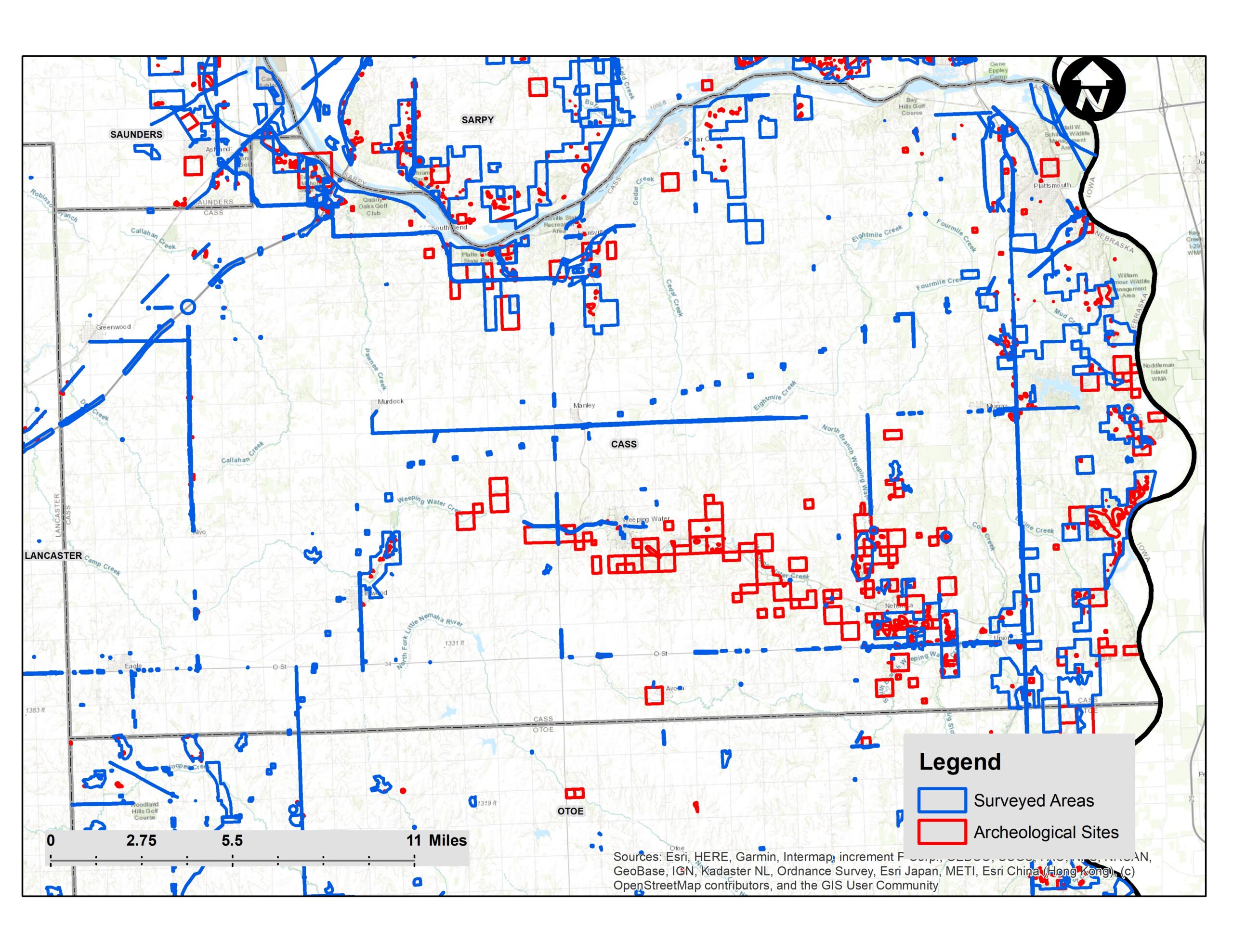
Map of Cass County showing density of archeological sites and surveys.

Map of Sioux County showing density of archeological sites and surveys.