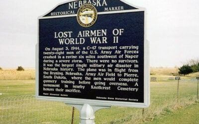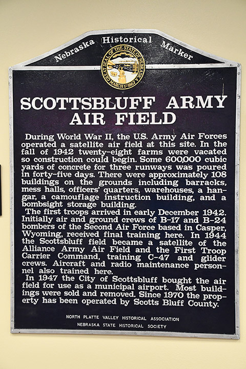
Marker Text
During World War II, the U.S. Army Air Forces operated a satellite airfield at this site. In the fall of 1942 twenty-eight farms were vacated so construction could begin. Some 600,000 cubic yards of concrete for three runways was poured in forty-five days. There were approximately 108 buildings on the ground including barracks, mess halls, officers’ quarters, warehouses, a hanger, a camouflage instruction building, and a bombsight storage building.
The first troops arrived in early December 1942. Initially air and ground crews of B-17 and B-24 bombers of the Second Air Force based in Casper, Wyoming, received final training here. In 1944 the Scottsbluff field became a satellite of the Alliance Army Air Field and the First Troop Carrier Command, training C-47 and glider crews. Aircraft and radio maintenance personnel also trained here.
In 1947 the City of Scottsbluff bought the airfield for use as a municipal airport. Most of the buildings were sold and removed. Since 1970 the property has been operated by Scotts Bluff County.
Location
Apron Dr, Western Nebraska Regional Airport (BFF), Scotts Bluff County, Nebraska. View this marker’s location HERE.