Now that we’ve learned why archeology is done—particularly through the lens of state and federal legislation (such as the Section 106 process) that mandates archeological work be completed—we can start exploring how archeology is done. Specifically, we’ll look at some techniques and tools archeologists use to know where to look for archeological sites and highlight the steps archeologists follow to locate them. Knowing where to look for a site and actually finding one are opposite sides of the same coin. Just because conditions, topography, or location may be ideal for an archeological site to be present doesn’t mean one is, nor that a site will be found if it is present. Like the old cliché saying, it can truly be like trying to find a needle in a haystack.
How are sites formed?
Archeologists study the physical remains¹ that people left behind in the past, so archeologists are interested in finding the locations where those people occupied. Whether an occupation occurred over the short or long-term, past peoples left behind evidence in the form of landscape modification and trash or other refuse—food debris, broken pots and tools, abandoned structures, fire pits—that tell us how they lived, what they ate, how they interacted with the environment and other populations, and more.
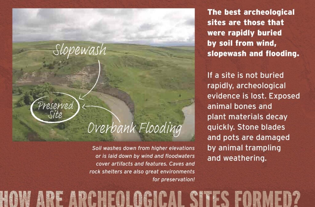
Description of how archeological sites are formed and preserved. From the Piecing Together the Past exhibit at the Nebraska History Museum.
Most of these items do not last a long time, especially if left exposed to the open air. Site preservation happens best when rapid burial occurs (rapidly, in a deep time sense of years or decades, not always necessarily hours or days) from flooding, wind-blown sediments, slope erosion, ash fall (think Pompeii!), or other similar processes and preserves evidence of the occupation. Then, after being buried for dozens, hundreds, or thousands of years, various processes such as erosion, animal burrowing, agricultural activity, and urban development can expose evidence of a site for archeologists to find. Some features of archeological sites, such as mounds, depressions, or foundations, may also help archeologists identify them without any other occupation remnants visible.
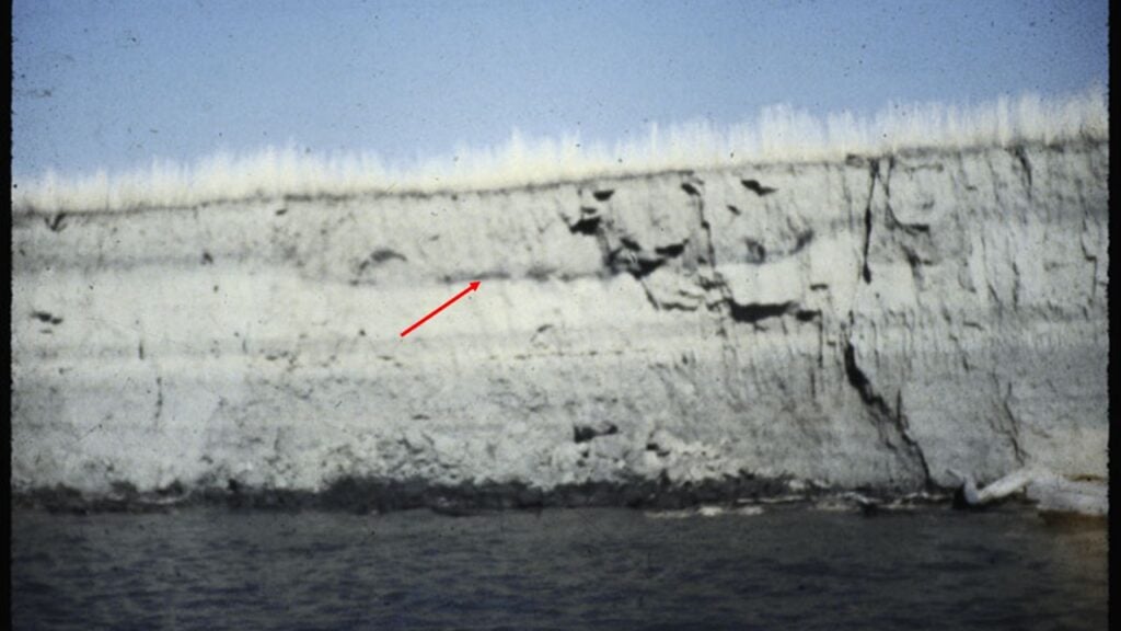
Eroded river cutbank exposing the floor of a Central Plains tradition earthlodge (dark line pointed out by red arrow). Note the thick layer of sediment over the house floor from previous flooding events.
Related to rapid burial, distance from water is one of the single most important factors in determining whether an archeological site should be present or not. Rivers, streams, lakes, ponds, or springs provide not just water for drinking and cooking with, but also locations that attract animals to hunt and collect (like shellfish). Water-adjacent environments also typically allow timber growth for firewood and building structures, and can provide clay suitable for the creation of pottery vessels.
How do archeologists know where to look?
Background Research
When a project request is received by one of the State Archeology Office (SAO) teammates, the first step involves conducting background research on the project’s area of potential effects (APE), as defined in the Section 106 regulations (36 CFR § 800.4). Within these regulations, the agency or individual completing a project is expected to make a “reasonable and good faith effort” to review existing information and seek additional information about historic properties–archeological sites in this case–known or not yet identified within the APE. Then, field investigations that may include walking surveys and subsurface testing are undertaken to review previously recorded sites, identify new sites, and assess the historical significance of those sites.
The background research may include, among other things, reviewing records of previously documented archeological sites and archeological surveys within the APE, examining historic and modern maps and aerial imagery to identify the presence or absence of features indicative of human occupation or modification (such as agricultural activity, building construction or demolition, and depressions or mounds), and consultation with Native American tribes. In addition to those types of records, archeologists will examine data regarding soil types, landforms, topography, and proximity to water to assess the likelihood of any yet unknown archeological sites within the project area. Through statutory requirement, the SAO is the central clearinghouse for all of Nebraska’s archeological information and is mandated to maintain a master site file and both a permanent repository and an electronic database of resources, and ensure the long-term curation and management of archeological collections. Previously recorded archeological sites that intersect the APE are generally relayed to the project client so they can determine if the project will impact the site or if project plans can be revised. If a site cannot be avoided, additional steps must be taken to document the site and assess its significance for listing in the National Register of Historic Places (NRHP).
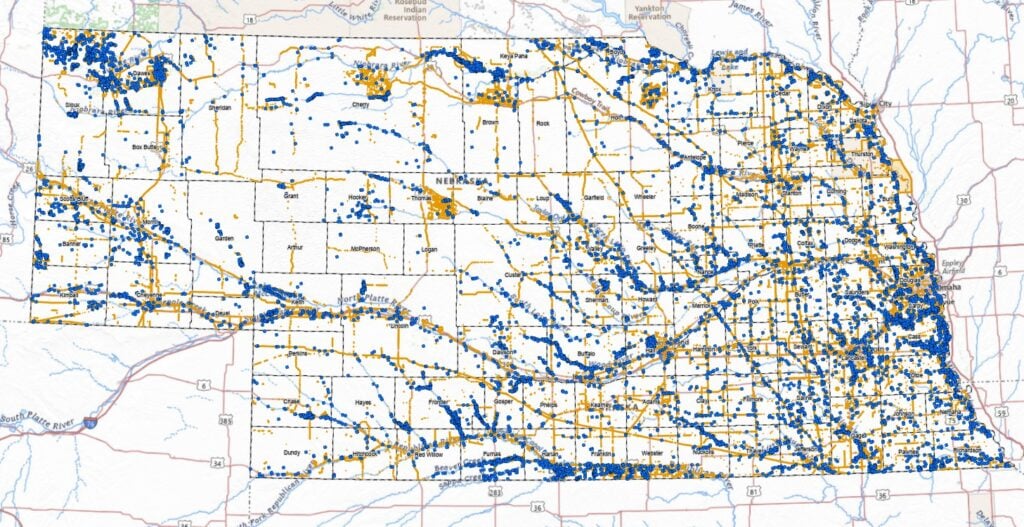
Map of Nebraska showing all documented archeological sites (blue dots) and archeological surveys (orange areas) across the state. Each dot and orange area has associated digital and physical resources (documents, maps, photographs, artifacts) associated with it, which are housed at the SAO in Lincoln.
Field Investigation
With information gathered from completing background research, archeologists will identify locations within the project APE to conduct field investigations in areas where no investigations have previously occurred, in areas where archeological sites have previously been documented, and/or in areas where the probability of an archeological site being present is high. Through the entirety of field investigation, archeologists meticulously gather information in the form of field notes, photographs, GPS data, hand-drawn maps, and completed forms of various types (FIGURE 4). Because archeology is, largely, inherently destructive—meaning once a site is excavated or artifacts are collected, archeologists can never put the site back exactly as it was found—all of this documentation helps archeologists rebuild the layers, contexts, and relationships of artifacts and features after the fact.
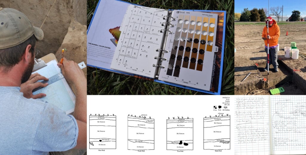
Different techniques archeologists use to document archeological sites, including (clockwise from left) drawing maps, describing soil colors, collecting GPS data, writing field notes, and illustrating site stratigraphy.
Most commonly, these locations are examined using pedestrian survey where the archeologists simply walk across the project area to identify any artifacts, ground modifications, disturbances, or other indications that an archeological site is present (FIGURE 5). Within the project APE, areas with greater levels of surface visibility, such as cutbanks, animal back dirt piles, eroded landforms, and places devoid of vegetation, are closely scrutinized. Pedestrian transects across the project area are evenly spaced—generally varying from 10 and 30 meters (33 to 98 feet) between transects—and meander throughout the APE. As artifacts or features are identified, they are marked, usually with colorful pin flags, and documented with a GPS unit or hand-drawn on a map.
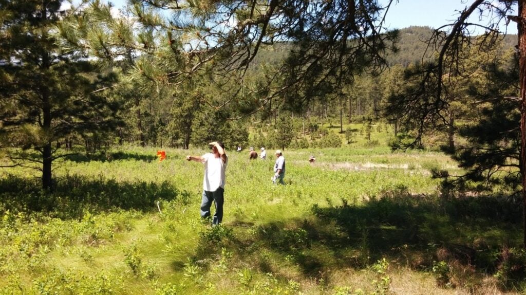
Archeologists conducting pedestrian survey across a project area.
In cases where surface visibility is low or non-existent, other techniques may be used to identify a site. A couple of these techniques include subsurface testing or the use of non-invasive geophysical tools, like ground-penetrating radar. Subsurface testing, usually done by hand with shovels or augers, is completed systematically across a project area by placing the tests at regular intervals across areas with high potential for buried archeological materials, such as level terraces or ridgetops. As with pedestrian survey, each subsurface test location is documented, and details about each test, such as soil depth, color, and texture, and presence/absence and depth of artifacts, are collected.
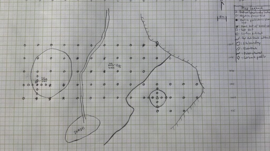
Example hand-drawn site plan map showing subsurface testing locations, surface artifacts, and other features of note at an archeological site.
While it may seem that the spacing of pedestrian transects or subsurface testing leaves the possibility for sites to be missed, these approaches are tried and true across decades of archeological practice. It is true that not all sites will be identified using any or all these techniques—we can walk the same field at different points in time and not relocate the same artifacts or features that make up the archeological site. But when factoring in the background research, as well as professional experience and judgment, archeologists tend to be successful in identifying sites where they should be. There are also contingencies put in project plans to notify the SAO and other appropriate agencies if cultural materials are encountered during construction activities.
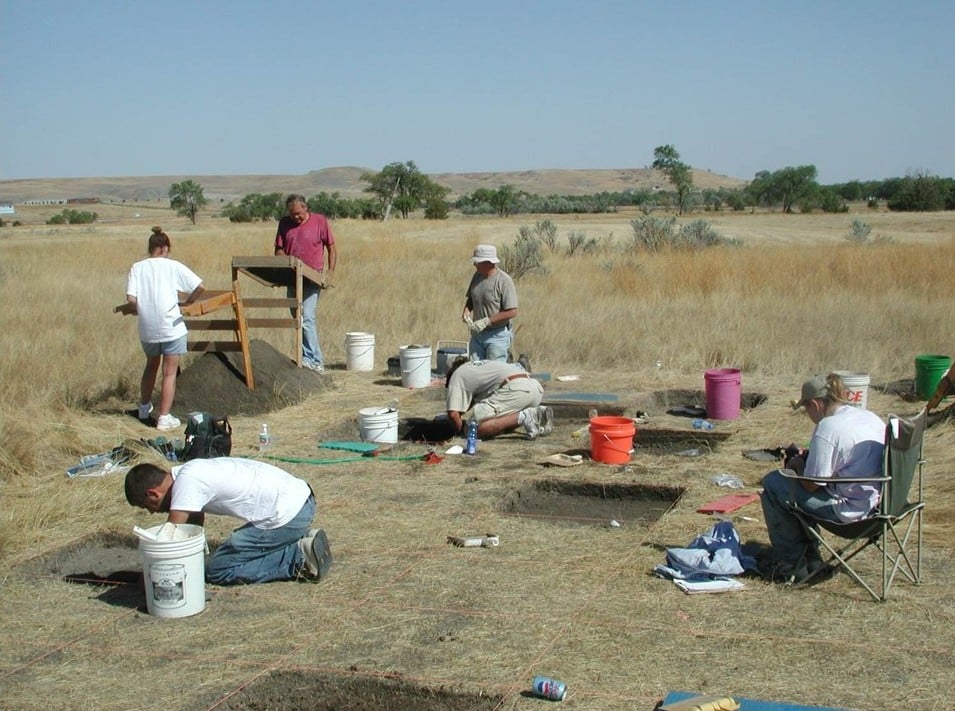
Archeologists conduct an evaluative excavation on a site to determine its historical significance.
Once an archeological site is identified, its location and information about what’s there are shared with the project client to determine whether the site can be avoided or if it will be impacted. If the site will be impacted and its significance regarding the NRHP hasn’t been considered, more rigorous evaluation testing needs to be completed. This part of the process involves excavation of larger areas, typically in the form of several 1 x 1-meter (3.3 x 3.3-feet) square units, backhoe trenches, or large, gridded, excavation blocks. This evaluative testing is used to collect additional data about the archeological site, such as how many artifacts or features are present; the condition and level of intactness of those artifacts or features; whether the materials present are associated with particular people or events of historical significance; whether there are any unique architectural features; or whether the site offers new, interesting, or additional research potential about the cultural period(s) represented there.

Excavation grid after completion of evaluative excavation.
The last step of fieldwork is mitigative excavation—excavation at an archeological site to recover as much data as possible before a project heavily disturbs or outright destroys the site. Mitigative excavation will be discussed in a future post.
The Sharp Homestead
In the case of the Sharp Homestead (25ST16), this review process began in 2019 when the SAO’s Highway Archeology Program (HAP) team received notice of the proposed Highway 275 expansion project between Wisner and east of Norfolk. Having received an initial project description and APE footprint, the HAP started by conducting the necessary background research. Records indicated that several previously recorded archeological sites were present within the APE; one of those sites was the Sharp Homestead (25ST16). It was determined early in the planning process that the site could not be avoided by the planned construction, so thorough site documentation and data recovery activities were planned.
The Sharp Homestead site file began in 1991 when the site was first documented by the HAP for an earlier NDOT project. At that time, the site was documented as a scatter of Historic period Euro-American artifacts, as well as four depressions in a field at the location of what was “alleged to be the first homestead in Stanton County” (SAO Site Files). The initial site form also indicated that, according to local informants, the buildings on the property had been torn down within the previous 10 years, presumably to turn the entire parcel into farmland. It is unclear whether any of those buildings were original to the Sharp occupation.
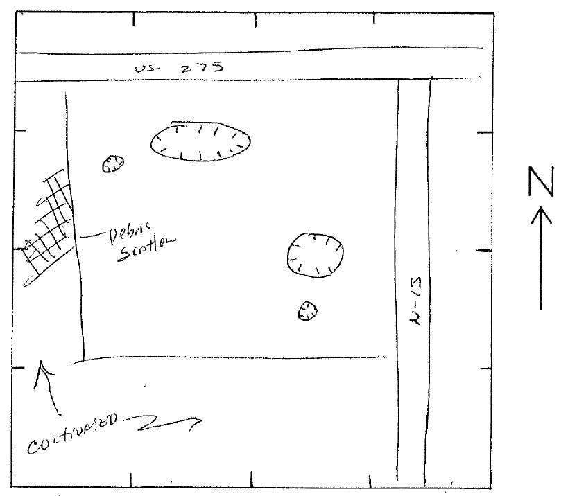
Sharp Homestead sketch map following 1991 site visit.
In 2012, another NDOT project led to another HAP crew conducting additional field survey, site testing (which involved stripping portions of the topsoil to identify if any intact archeological features were present), and more comprehensive background research resulted in the site being recommended as Potentially Eligible for listing in the NRHP. Construction following the 2012 work did not impact any intact features or significant artifact deposits associated with the homestead, and the bulk of the documented site boundary was left unaffected.
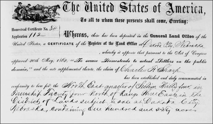
September 1872 land patent certificate issued to Charles Sharp.
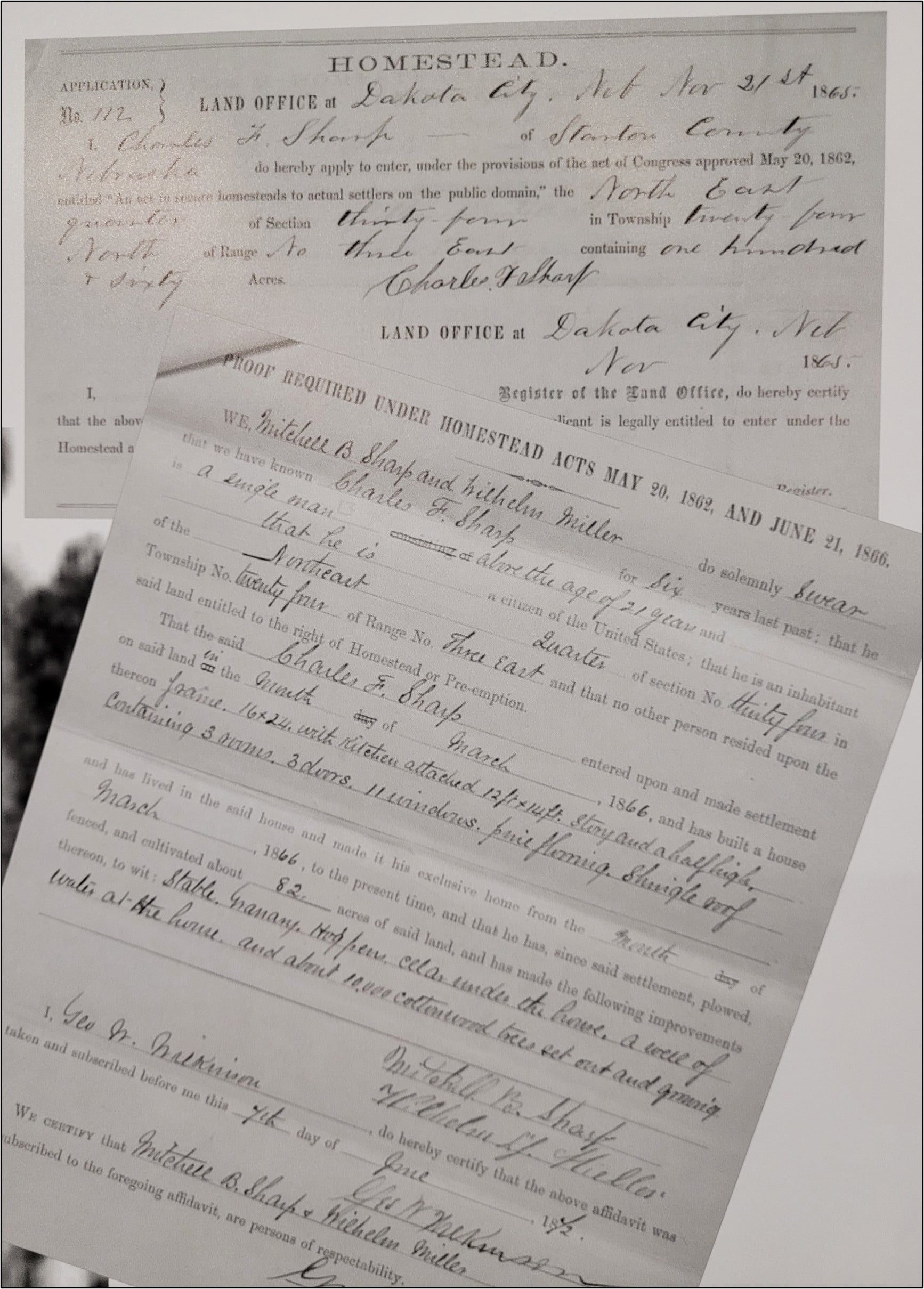
November 1865 homestead patent to Charles Sharp (top), and June 1872 homestead improvements documentation (bottom).
For the 2019 project, in addition to reviewing available site files, HAP archeologists sought out archival documents to confirm the homestead as the first in Stanton County and support the recommendation that the site was eligible for NRHP listing. Among the documents found were the November 1865 homestead patent granted to Charles Sharp, a June 1872 document outlining homestead improvements, and a September 1872 land patent certificate. Additional information about the property comes from a county plat map from 1899 showing a structure mapped in the same location that the Sharp family built their homestead. By that time, ownership had changed to Carl Ohman.
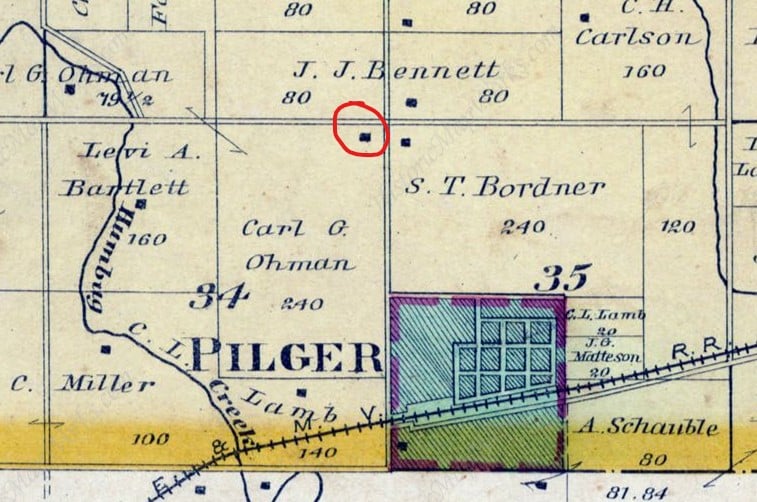
1899 county plat map showing the location of a structure where the Sharp Homestead was constructed over 30 years earlier. Red circle indicates the structure in question. Source: Plat Book of Stanton County, Nebraska. Northwest Publishing Co., 1899.
The homestead and land patent documents and historic plat map confirmed early homesteader occupation on the property, though no imagery of the home or other buildings has yet been found. The earliest photograph found showing the Sharp Homestead is from 1940 and highlights a large farmstead with a house and several outbuildings surrounded by agricultural fields. What isn’t clear in the photo, or any other documentation found to date, is whether any of the structures shown were original to the Sharp family’s occupation of the property starting in the 1860s, or even the building shown in the 1899 plat map.
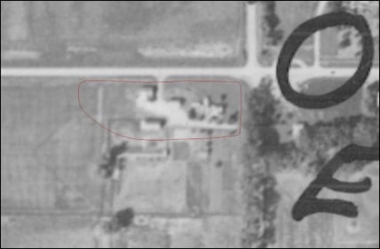
1940 aerial photograph showing the location of the Sharp Homestead (red boundary).
Knowing that the site would be adversely affected by highway construction, a mitigation plan was developed to recover as much data as possible about the site before construction. Because of the large site size and due to time and cost constraints, it was deemed necessary to develop a detailed data recovery plan that would target mitigative excavation on specific areas of the site. In order to assist with identifying locations suitable for excavation, namely what the archeologists hoped would be features associated with the 1860s homestead, the HAP team worked with archeologists at the Midwest Archeological Center (MWAC), a program of the National Park Service, to conduct a comprehensive multi-instrument geophysical investigation of the site. In the summer of 2019, the combined MWAC and HAP crew surveyed the site using a magnetic gradiometer, electromagnetic induction meter, and resistance meter.
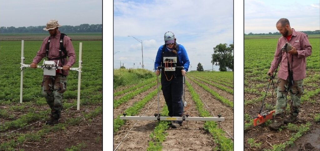
MWAC archeologists completing a multi-instrument geophysical survey of the Sharp Homestead.
Data collected from the three instruments yielded substantial data indicating a number of subsurface anomalies of archeological interest. Based on those locations, the HAP team was able to finalize a data recovery plan to mitigate the adverse effects of the planned highway construction. That plan involved excavation to expose those anomalies with the hope that they represented features associated with the earliest occupation of the Sharp Homestead site.
Through a combination of background research, field survey, limited subsurface testing, and geophysical investigation, Nebraska archeologists discovered and documented the Sharp Homestead, a historically significant property representing some of the earliest Euro-American occupation in the state. Next, we’ll explore how the mitigative excavation was completed and some of the challenges archeologists faced when digging at the site.
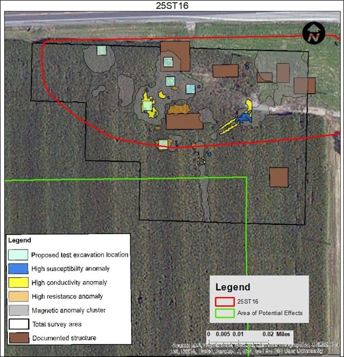
Results of the geophysical survey at the Sharp Homestead and proposed mitigative excavation areas to explore anomalies identified during survey.
Footnote:
- These physical remains are broadly defined in two classes: artifacts and features. Artifacts are the portable physical remains that people made, used, ate, or otherwise altered, such as arrowheads, pottery, clothing, glass bottles, and more. Features are non-portable physical remains or landscape modifications that represent other aspects of human behavior, such as cooking hearths, house foundations, depressions, or mounds. Archeological sites are comprised of different combinations of artifacts and/or features.
(Posted September 16, 2025)